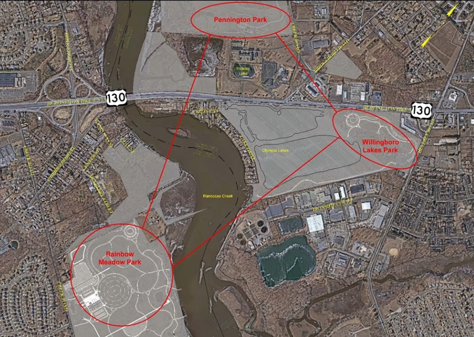
How to best connect Pennington Park, Willingboro Lakes Park and Rainbow Meadow Park (formerly Laurel Run Park)?
That is the question.
The first public information meeting was held on April 1 regarding the intersection study for Rancocas Creek Greenway Route 130/Rancocas Creek Crossings, with a presentation focused on connection and safety and a question-and-answer portion.
Burlington County, in partnership with the Delaware Valley Regional Planning Commission (DVRPC), is conducting a Local Concept Development (LCD) study to identify, evaluate and advance a safe and feasible extension of the Rancocas Creek Greenway Trail across Route 130 and the Rancocas Creek.
Matt Johnson, coordinator of the county’s Open Space Acquisition and Park Development Program; Dale Foster, vice president and senior project manager for GPI (Greenman-Pederson Inc.); Charles Calimer, civil/highway engineer for GPI; and Steven Lennon, director of projects for Taylor Design Group, lead the local concept development study.
The study marks the first phase of the federally funded transportation improvement work. It includes collecting data; meeting with municipal officials, stakeholders and permitting agencies, as well as the public; developing a practical range of alternatives; and then recommending the preliminary preferred alternative, officials said.
The project aims to connect three county park properties – Pennington, Willingboro and Rainbow Meadow Park – with surrounding neighborhoods and the regional Circuit Trails network. The segment of the Greenway Trail presents the most significant challenge: It will provide a continuous, safe alignment for bicyclists and pedestrians.
Rancocas Creek is a navigable fresh water tributary for the Delaware River. It is tidal, with 6 feet of change between tides. Within the project area, its narrowest width changes between 425 to 525 feet, and current tidal mud flats extend several hundred feet beyond the main channel, according to the presentation.
Route 130 is an urban principle arterial with six through lanes, high traffic and a post speed of 50 miles per hour. The study area contains multiple ramps and two major intersections, one between Route 130 at Bridgeboro Road and the other at Beverly Road.
There are no sidewalks, crosswalks or Americans with Disabilities Act (ADA)-compliant curbs or ramps.
The lack of pedestrian and bicycle facilities diminishes driver awareness of non-motorized users, creating hazardous conditions. The existing Route 130 bridge includes only a narrow, disconnected sidewalk on the northbound side.
The presentation offered possible alternatives connecting the county parks through the Circuit Trails network. Connections are important to get people where they live, work and play, officials said. Opportunities are needed regardless of age or ability.
Safety is key.
The Circuit Trails – a vast regional network of hundreds of miles of multi-use trails that is growing in size each year – connects the Greater Philadelphia and southern New Jersey region; counties; and local communities, providing opportunities for recreation and commuting.
The next meeting on the road connections will be held next month. Officials are narrowing down alternatives and presenting the best alternative.